services


Ground Penetrating Radar Surveying (GPR)
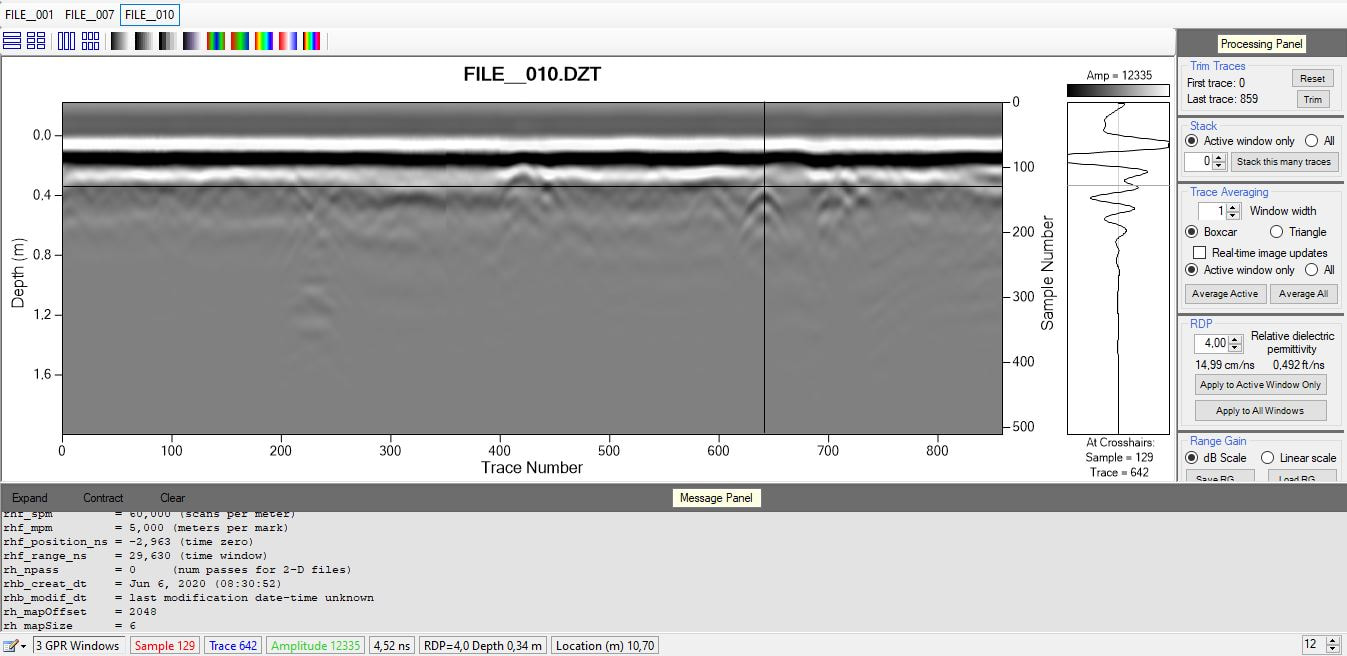
Ground Penetrating Radar (GPR) is one of the most accurate non-destructive surveying methods available and offer the means to detect subsurface objects that are not detectable by other methods. This high-resolution geophysical method uses radar pulses to locate and image subsurface objects, and in addition to detecting metal objects, GPR is also able to detect non-metal objects(ie plastic water pipes and concrete pipes). Compared to other non-destructive methods such as infrared thermography and ultrasonic, GPR offers more penetrating power. The use of GPR is also extremely safe and only emits about 1% of the power of a cell-phone signal. |

The GPR's antenna consists of a control unit, a transmitter and a receiver. The transmitter sends a high-frequency radar pulse into the ground where it is refracted, diffracted and reflected as it encounters changes in dielectric permittivity and electric conductivity. The pulses then induce a signal in the receiving antenna that is recorded as a digitized signal for display, interpretation and further analysis .
|


Electromagnetic Scanning and Locating (EML)
The Electromagnetic Locator (EML) or Utility Avoidance tool is used for locating and tracing utility lines and metallic pipes for excavation and drilling locations. The locator is necessary not only for undertaking safe excavation, but also for fault finding, by tracing the route of the line. These locators are cutting-edge technology and consist of two main parts, a transmitter and a receiver. The transmitter emits a frequency selected by the operator that induces onto nearby pipes and cables. The receiver detects these radio frequencies, and the operator is able to accurately locate and trace the pipes and cables. The vScan EML is able to locate pipes or cables via passive location or active location. Passive locating refers to the process of detecting signals that "naturally" occur on pipes and cables. These tend to fall into two categories, Radio Signals and Power Signals. Radio Signals are created by low frequency radio transmitters. These are used for broadcasting and communications. They are positioned throughout the world. As the frequencies are very low the signals tend to penetrate and hug the curvature of the earth. When the signals cross a long conductor such as a pipe or cable, the signals are re-radiated. It is these re-radiated signals that can be detected by the Radio Mode. Power Signals are created by mains power running in the supply cables. When electrical power is distributed throughout the network, some of the power finds its way back to the power station via the ground. These stray currents can jump onto pipes and cables and also create power signals. Note that there has to be electrical current flowing to create a detectable signal. |

Active Locating describes the action of locating a cable or pipe by detecting a specific signal that has been injected into that line. It has the benefit that, unlike passive detecting, the operator is in control of
the signals and therefore can be more specific about what line is detected. That is to say active signals can be used for line tracing or identification. Also Passive signals are not always present on a line so using active signals ensures more lines are detected. |


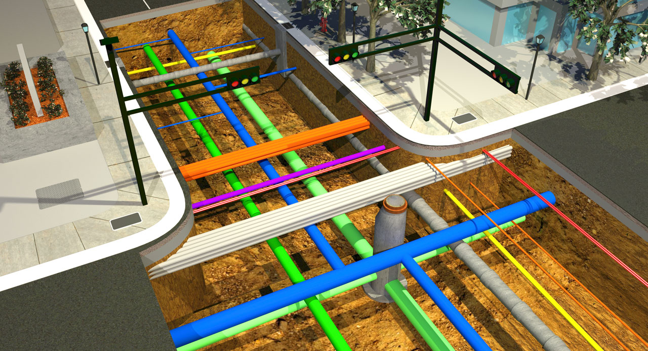
Utility Locating
Damage to underground utilities could have costly implications as well as cause serious injuries. By making use of GeoScan's dedicated utility locating services, these implications can be avoided. GeoScan uses state-of-the-art technologies including Ground Penetrating Radar (GPR), Radio Frequency Locators (RFL) and Electromagnetic Locators (EML) to conduct surveys. By combining these technologies GeoScan is able to detect and locate metallic as well as non-metallic subsurface utilities. If you need to locate underground utilities on site for trenching, drilling, excavation or building projects, GeoScan will locate and mark objects on site. Complete reporting and mapping is available as per client requirements and specifications. |

|

Subsurface Profiling, Reporting and Mapping
During the course of the survey, all subsurface objects and utilities located are indicated on site with markers(ie paint, pegs etc.) For safe excavation, trenching or drilling and to avoid costly mistakes, drawings of subsurface utilities and other underground objects must be accurate and up to date. Existing conditions will likely differ from any original plans and in many cases plans do not exist or are outdated and vague. Profiling can commence once a thorough survey of the indicated area has been completed and entails the extrapolation of data collected via the survey. The survey data can then be interpreted and analised for further reporting and mapping. |

As per the client's requirements a complete survey report can be produced including the survey route, GPS co-ordinates, site photos, survey data as well as a written report.
A detailed, accurate map of the subsurface environment can also be created. These subsurface maps will assist in reducing project planning time, minimising risk, and to comply with health & safety regulations. |


Horizontal Directional Drilling (HDD) Drill Plans
For Horizontal Directional Drilling projects, GeoScan produces HDD drill plans based on geophysical surveys and data collected. These plans will assist the drill operator in selecting the best possible drill path in order to avoid damage to any subsurface utilities. |

|